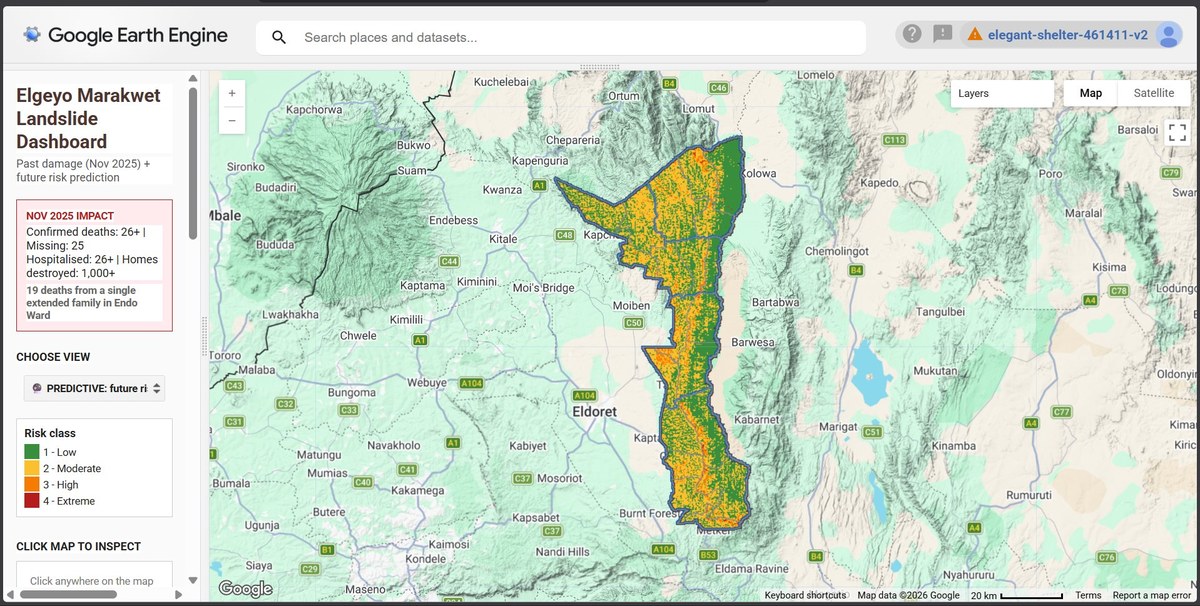
Elgeyo Marakwet Landslide Dashboard
Google Earth Engine Hazard Mapping Predictive Modelling Disaster Risk
Overview
A Google Earth Engine (GEE) application combining past damage mapping with predictive future risk classification for landslides in Elgeyo Marakwet County, Kenya — a county whose dramatic Kerio Valley escarpment makes it one of the most landslide-prone regions in East Africa.
The dashboard lets users toggle between a historical view of the November 2025 disaster and a predictive risk map classifying every pixel of the county's terrain into four risk classes.
The November 2025 Event
November 2025 Impact
- Confirmed deaths: 26+
- Missing: 25
- Hospitalised: 26+
- Homes destroyed: 1,000+
- 19 deaths from a single extended family in Endo Ward
The November 2025 landslides were among the deadliest in Kenya's recent history. The Endo Ward tragedy — where 19 members of one extended family were killed — illustrated how concentrated landslide exposure can be when vulnerable communities live on high-risk slopes without early-warning systems.
What I Built
A dual-mode GEE application with two views:
1. Past Damage (November 2025) Mapping of affected areas using satellite-derived change detection over the escarpment terrain.
2. Predictive: Future Risk A risk classification model producing a four-class risk surface:
| Class | Risk Level |
|---|---|
| 1 | Low |
| 2 | Moderate |
| 3 | High |
| 4 | Extreme |
Users can click any location on the map to inspect its risk class — enabling ward-level planning conversations.
Tools & Methods
| Tool | Purpose |
|---|---|
| Google Earth Engine | Cloud-based satellite analysis & app hosting |
| JavaScript (GEE API) | Application logic and UI |
| DEM / slope analysis | Terrain susceptibility inputs |
| Satellite imagery | Pre/post-disaster change detection |
| Kenya administrative boundaries | County and ward overlays |
Why This Matters
Kenya lacks a systematic, publicly accessible landslide early-warning system. This dashboard demonstrates that GEE can power near-real-time risk tools that don't require local server infrastructure — making them viable for county disaster management offices with limited IT capacity.
Year
2025 – 2026